Monday, December 26, 2011

Blog Post #4: Earthquakes

New Madrid Seismic Zone


Even though there aren’t any visible plate boundaries in the middle of the United States, there is evidence of earthquakes occurring in the area. There are records of earthquakes occurring in 1811 and 1812 that were felt from Mexico to Canada. There is proof showing that those years were not the first time that earthquakes occurred there. A PBS NOVA video explains how stalagmites in caves prove that earthquakes did in fact occur. The rings are not counted as tree rings are counted. Instead the age of the layers are analyzied with chemicals. The stalagmites show evidence of violent earthquakes.


The ground in New Madrid, Missouri is actually an epicenter of the most active seismic zone to the east of the Rocky Mountains. This is the New Madird Seismic Zone, as a CUSEC article. The NMSZ is definitely a threat to the United States, that most people are not even aware about. An earthquake could strike at any time.

The Missouri Department of Natural Resources stated that “Due to the harder, colder, drier and less fractured nature of the rocks in the earth’s crust in the central United States, earthquakes in this region shake and damage an area approximately 20 times larger than earthquakes in California and most other active seismic areas.” This means that if an earthquake occurred they would be far worse than the ones we hear about happening at the San Andreas Fault.

One interesting theory for why the NMSZ is there sense is that the region lays over an ancient wound deep in the earth’s crust. It is thought that plates that were being pulled apart by tectonic forces suddenly stoped moving apart from each other. This “failed rift” created a weak spot in the crust which could be causing this seismic activity and occasional earthquakes.


Sources:


Blog Post #3: Glaciers

Greenland Melting

Greenland has become a symbol of global warming as the massive ice sheet that covers it is melting at a much faster rate. The Greenland ice sheet extends over 1000 miles, which is over 80% of the landmass of Greenland. It is melting at an unprecedented rate and as it melts, the edges start to break apart and fall into the water. Crashes can be heard nearby as the chunks of ice fall into the water. 10% of the world’s fresh water is frozen in Greenland, which is enough to raise sea level 23 feet globally. This is where the “global meltdown” begins.


According to a UK newspaper article in The Telegraph, an “area of ice three times the size of Manhattan Island” broke off between July 28th and August 5th in 2010. This photo shows the massive chunk breaking off.


As scary as it may seem to live in Greenland, there is a population of about 56 thousand.  What may be even more shocking is that the melting is beneficial to residents of Greenland. The documentary I Heart Global Warming explains how new areas of land are being uncovered due to the warming temperatures. This is exposing land that can now be explored. There are economic benefits of the melting because of all of the oil, gas, and minerals that can now be found. They are finding precious metals in the ice. There has even been success with selling bottled glacial melt water.

An article on thinkprogress.org explains how researchers are finding that “even if you don’t have record-breaking highs, as long as warm temperatures persist you can get record-breaking melting because of positive feedback mechanisms.” This cycle of warming and melting is very difficult to halt. The I Heart Global Warming documentary concludes with a powerful statement: “We’ve awakened a giant. And whatever we did to cause this, there’s no turning back. There’s no more preventing it. Maybe we can slow it down- we can still blunt its force. But it’s coming.”


Sources:


Monday, November 14, 2011

Blog Post #2: Climate

Polar Ice Caps Melting

The poles are melting. Whether you believe in “global warming” or not, you cannot deny the fact that polar bears are losing their homes. The earth is warming, the ice is melting, and as a result, the water is rising. Being able to see a trend in the melting that has already occurred is the key in predicting what will become of our future Ice sheets. There are so many aspects of global climate change to look at, but this one is quite visual.

The EPA explains how the Arctic is expected to be the part of the world with the greatest amount of warming because its albedo will change significantly as the ice melts. The reflectivity of the ice will turn into absorption. Therefore, the amount of heat held at the Arcitc will increase drastically. Satelitte data shows that the amount of ice has decreased by about 3% per decade since 1860.

NASA’s article, NASA Finds Polar Ice Adding More to Rising Seas, suggests that the rate that ice sheets are melting is accelerating the rate of sea level rising much faster than expected. It is also shown that the amount of ice mass being lost is increasing year after year. For example, the amount of ice mass being lost this year in 2011 is greater than what was lost in 2010, which is greater than what was lost in 2009, and so on.

The Earth Science Department at the University of California backs up the idea that the amount of melting is increasing year after year.  It is uncertain to tell what the exact future will hold.  Their article, Melting Ice Sheets Now Largest Contributor  to Sea Level Rise, states that ice sheets hold a much higher mass than mountain glaciers.


Sources:


http://www.ess.uci.edu/news/searise201103

Blog Post #1: Weather

Hurricane Irene

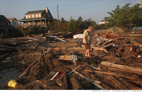
Hurricane Irene, of late August, 2011, was something to worry about along the East coast, all the way up to New England. She was a “disappointment” to some, while others saw destruction that they had only seen on television before. Some people took it seriously-maybe too seriously- and others blew it off in denial believing that it was nothing to be concerned about. The outcome of Irene’s presence, or lack-there-of, is interesting to follow up on two months later.

         NPR’s article entitled Irene: Wet, Deadly and Expensive as Cleanup Begins describes how New Englanders for the most part were not well prepared for Irene. In some places, they were not expecting the hurricane to be as powerful as it was, or not even reach them at all. The flash flooding was also much worse than anticipated. The flooding caused other devastation and destruction, too. On the other hand, some people that were very prepared for Irene did not get affected much by the storm. Irene hit places that hurricanes do not generally reach, and she left some of the usual areas to be struck hard alone. 

        NASA’s article, Rainfall from Hurricane Irene, discusses how Hurricane Irene brought enough rain to cause disastrous flooding.  The rainfall lasted all the way up through New Hampshire and Vermont and caused damage that was not expected. The article explains how two places that receive the same amount of rainfall can have very different outcomes. This is because the severity of flooding is dependent on other factors, such as vegetation and land use. This explains why Vermont was hit so much harder than other states.

            CNN’s article, Hurricane Irene Damage Could Reach Billions, discusses the impact that Irene had on the east coast. Although not as severe as it could have been, the hurricane caused a considerable amount of damage, and a few dozen deaths. Power outages were a huge issue with the hurricane. Some were without power for over a week. The article describes how the hurricane was weakened by the fact that it hit land three separate times on its way up the east coast. This is why some places along the coast did not get hit so bad from the storm. Thankfully, the storm did not cause nearly as much damage as Hurricane Katrina. However, the storm did bring the east coast surprises that most of us were not expecting.


Sources: